
Sywell topographic map
Click on the map to display elevation.
About this map
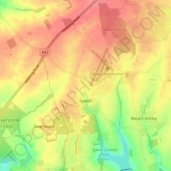
Name: Sywell topographic map, elevation, terrain.
Location: Sywell, North Northamptonshire, England, United Kingdom (52.27825 -0.81795 52.32380 -0.77645)
Average elevation: 113 m
Minimum elevation: 72 m
Maximum elevation: 139 m
Other topographic maps
Click on a map to view its topography, its elevation and its terrain.
Irchester Country Park
United Kingdom > England > North Northamptonshire > Little Irchester
Average elevation: 60 m
River Nene Navigation
United Kingdom > England > North Northamptonshire > Irchester
Average elevation: 55 m