
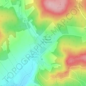
Château de Louvois topographic map
Interactive map
Click on the map to display elevation.
About this map
Name: Château de Louvois topographic map, elevation, terrain.
Average elevation: 174 m
Minimum elevation: 104 m
Maximum elevation: 273 m
Other topographic maps
Click on a map to view its topography, its elevation and its terrain.
Hameau de Vertuelle
France > Grand Est > Marne > Val de Livre
Hameau de Vertuelle, Louvois, Val de Livre, Épernay, Marne, Grand Est, France métropolitaine, 51150, France
Average elevation: 214 m
Louvois
France > Grand Est > Marne > Val de Livre
Louvois, Val de Livre, Épernay, Marne, Grand Est, France métropolitaine, 51150, France
Average elevation: 207 m
Tauxières-Mutry
France > Grand Est > Marne > Val de Livre
Tauxières-Mutry, Val de Livre, Épernay, Marne, Grand Est, France métropolitaine, 51150, France
Average elevation: 158 m