
Hofstade topographic map
Interactive map
Click on the map to display elevation.
About this map
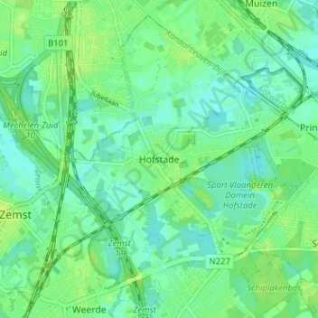
Name: Hofstade topographic map, elevation, terrain.
Average elevation: 8 m
Minimum elevation: 2 m
Maximum elevation: 14 m
Other topographic maps
Click on a map to view its topography, its elevation and its terrain.
Zemst-Bos
België > Vlaams-Brabant > Halle-Vilvoorde > Zemst
Zemst-Bos, Zemst, Halle-Vilvoorde, Vlaams-Brabant, Vlaanderen, 1980, België
Average elevation: 11 m
Elewijt
België > Vlaams-Brabant > Halle-Vilvoorde > Zemst
Elewijt, Zemst, Halle-Vilvoorde, Vlaams-Brabant, Vlaanderen, 1982, België
Average elevation: 9 m
Eppegem
België > Vlaams-Brabant > Halle-Vilvoorde > Zemst
Eppegem, Zemst, Halle-Vilvoorde, Vlaams-Brabant, Vlaanderen, België
Average elevation: 11 m