
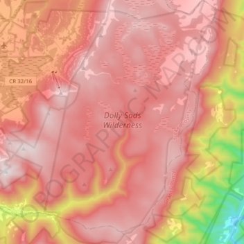
Dolly Sods Wilderness topographic map
Interactive map
Click on the map to display elevation.
About this map
Name: Dolly Sods Wilderness topographic map, elevation, terrain.
Average elevation: 1,042 m
Minimum elevation: 347 m
Maximum elevation: 1,351 m
Dolly Sods is a rocky, high-altitude plateau with sweeping vistas and lifeforms normally found much farther north in Canada. To the north, the distinctive landscape of "the Sods" is characterized by stunted ("flagged") trees, wind-carved boulders, heath barrens, grassy meadows created in the last century by logging and fires, and sphagnum bogs that are much older. To the south, a dense cove forest occupies the branched canyon excavated by the North Fork of Red Creek.
Other topographic maps
Click on a map to view its topography, its elevation and its terrain.
Otter Creek
United States > West Virginia > Tucker County
Otter Creek, Tucker County, West Virginia, United States
Average elevation: 914 m
Canaan Valley Resort State Park
United States > West Virginia > Tucker County
Canaan Valley Resort State Park, Pointy Knob Road, Tucker County, West Virginia, 26263, United States
Average elevation: 1,033 m
Davis
United States > West Virginia > Tucker County
Davis, Tucker County, West Virginia, United States
Average elevation: 955 m
Thomas
United States > West Virginia > Tucker County
Thomas, Tucker County, West Virginia, 26292, United States
Average elevation: 947 m
Fairfax Stone State Park
United States > West Virginia > Tucker County
Fairfax Stone State Park, Tucker County, West Virginia, United States
Average elevation: 913 m
Location
United States > West Virginia > Tucker County
Location, Tucker County, West Virginia, United States
Average elevation: 722 m
Parsons
United States > West Virginia > Tucker County
Parsons, Tucker County, West Virginia, 26287, United States
Average elevation: 556 m