
Make a donation
Gear up for your next adventure:
As an Amazon Associate, this site earns from qualifying purchases at no extra cost to you.
Winzenhohl topographic map
Click on the map to display elevation.
Make a donation
Gear up for your next adventure:
As an Amazon Associate, this site earns from qualifying purchases at no extra cost to you.
Winzenhohl
Das Dorf Winzenhohl liegt auf 220 m ü. NN an der Kreisstraße 2 zwischen Hösbach-Bahnhof und Haibach am Winzenhohler Bach. Der topographisch höchste Punkt der Dorfgemarkung ist der Gipfel des Kellerberges westlich des Ortes mit 330 m ü. NN, der niedrigste Punkt liegt an der Aschaff auf 147 m ü. NN. Durch Winzenhohl führt der Fränkische Marienweg.
Make a donation
Gear up for your next adventure:
As an Amazon Associate, this site earns from qualifying purchases at no extra cost to you.
About this map
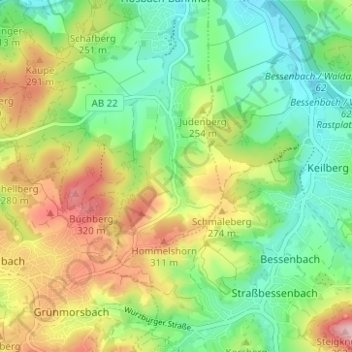
Name: Winzenhohl topographic map, elevation, terrain.
Average elevation: 228 m
Minimum elevation: 151 m
Maximum elevation: 350 m
Make a donation
Gear up for your next adventure:
As an Amazon Associate, this site earns from qualifying purchases at no extra cost to you.
Other topographic maps
Click on a map to view its topography, its elevation and its terrain.