
Numansdorp topographic map
Interactive map
Click on the map to display elevation.
About this map
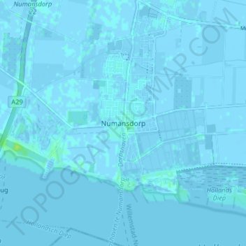
Name: Numansdorp topographic map, elevation, terrain.
Location: Numansdorp, Zuid-Holland, Nederland, 3281, Nederland (51.70662 4.41744 51.74662 4.45744)
Average elevation: 0 m
Minimum elevation: -4 m
Maximum elevation: 10 m
Other topographic maps
Click on a map to view its topography, its elevation and its terrain.
In- en uitlaatleiding gemaal Cromstrijen
Nederland > Zuid-Holland > Numansdorp
In- en uitlaatleiding gemaal Cromstrijen, Numansdorp, Hoeksche Waard, Zuid-Holland, Nederland, 3281 KK, Nederland
Average elevation: 0 m