
Make a donation
Gear up for your next adventure:
As an Amazon Associate, this site earns from qualifying purchases at no extra cost to you.
Palisades topographic map
Click on the map to display elevation.
Make a donation
Gear up for your next adventure:
As an Amazon Associate, this site earns from qualifying purchases at no extra cost to you.
Palisades
In 1800 the population of Palisades was 114. Because of the local topography the town was well suited to become a river center. Rising from the west bank of the Hudson River, the Palisades Cliff forms an obstacle to transport seeking access to the river. A break in the terrain occurs at Palisades, still known as Snedens Landing in the early 19th century, where the landscape is rugged but not precipitous. It afforded New Jersey farmers the opportunity to bring their produce down Washington Springs Road to the river, where they could ship it across to the east side of the Hudson and continue down to New York City. Also, at this time the city created a demand for quarried stones for use in paving streets and building houses. According to tradition, the stones cut from the Palisades Cliff paved many New York City streets, including Broadway. Snedens Landing provided these farmers and quarrymen with the first access for a stretch of about 13 miles above Burdetts Landing, or roughly the spot where the George Washington Bridge connects New Jersey and New York today. The town became so busy that a 500-foot pier was constructed. In the first half of the 19th century steamboats began plying the Hudson. The Sneden family, which continued to ferry passengers and goods across to Dobbs Ferry, also communicated with steamboat traffic, which could not dock in the shallow water at the shore, mid-river.
Make a donation
Gear up for your next adventure:
As an Amazon Associate, this site earns from qualifying purchases at no extra cost to you.
About this map
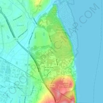
Name: Palisades topographic map, elevation, terrain.
Average elevation: 29 m
Minimum elevation: -3 m
Maximum elevation: 140 m
Make a donation
Gear up for your next adventure:
As an Amazon Associate, this site earns from qualifying purchases at no extra cost to you.