
Make a donation
Gear up for your next adventure:
As an Amazon Associate, this site earns from qualifying purchases at no extra cost to you.
Rockingham topographic map
Click on the map to display elevation.
Make a donation
Gear up for your next adventure:
As an Amazon Associate, this site earns from qualifying purchases at no extra cost to you.
Rockingham
The highest point in town is Berry Hill at 478 m/1568 ft elevation, near the northwestern corner of the town. The lowest point is on the Connecticut River at the southern boundary of town, at 73 m/240 ft elevation.
Make a donation
Gear up for your next adventure:
As an Amazon Associate, this site earns from qualifying purchases at no extra cost to you.
About this map
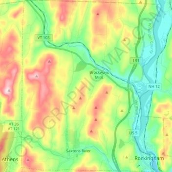
Name: Rockingham topographic map, elevation, terrain.
Location: Rockingham, Windham County, Vermont, United States (43.12503 -72.55798 43.23590 -72.43427)
Average elevation: 227 m
Minimum elevation: 66 m
Maximum elevation: 493 m
Make a donation
Gear up for your next adventure:
As an Amazon Associate, this site earns from qualifying purchases at no extra cost to you.
Other topographic maps
Click on a map to view its topography, its elevation and its terrain.