
Denham topographic map
Interactive map
Click on the map to display elevation.
About this map
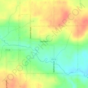
Name: Denham topographic map, elevation, terrain.
Location: Denham, Pine County, Minnesota, United States (46.35392 -92.95431 46.37214 -92.92785)
Average elevation: 375 m
Minimum elevation: 348 m
Maximum elevation: 401 m
Other topographic maps
Click on a map to view its topography, its elevation and its terrain.
Cloverton
United States > Minnesota > Pine County
Cloverton, New Dosey Township, Pine County, Minnesota, United States
Average elevation: 332 m
Pine County
United States > Minnesota > Pine County
Pine County, Minnesota, United States
Average elevation: 326 m
Jarvis Bay
United States > Minnesota > Pine County
Jarvis Bay, Pine County, Minnesota, United States
Average elevation: 286 m
Sandstone
United States > Minnesota > Pine County
Sandstone, Pine County, Minnesota, United States
Average elevation: 332 m