
Schendelbeke topographic map
Interactive map
Click on the map to display elevation.
About this map
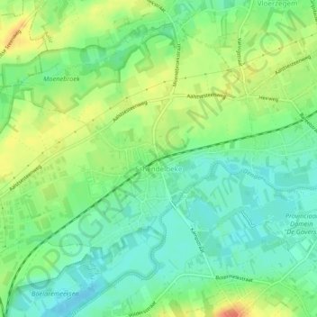
Name: Schendelbeke topographic map, elevation, terrain.
Average elevation: 24 m
Minimum elevation: 6 m
Maximum elevation: 51 m
Other topographic maps
Click on a map to view its topography, its elevation and its terrain.
Moenebroek
België > Oost-Vlaanderen > Aalst > Geraardsbergen > Schendelbeke
Moenebroek, Moenebroekstraat, Schendelbeke, Geraardsbergen, Aalst, Oost-Vlaanderen, Vlaanderen, 9506, België
Average elevation: 30 m