Geolocate

Cressing topographic map

Click on the map to display elevation.

About this map

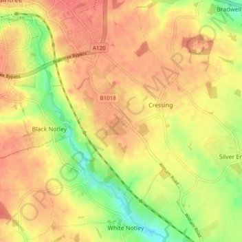
Name: Cressing topographic map, elevation, terrain.

Location: Cressing, Braintree, Essex, England, United Kingdom (51.83115 0.56550 51.87794 0.62631)

Average elevation: 57 m

Minimum elevation: 25 m

Maximum elevation: 74 m

Gear up for your next adventure:

🔭Compact Hiking Binoculars - Lightweight optics for scouting routes or birdwatching
📡Weather Radios - Emergency weather radios
🧢Outdoor Sun Hats - Sun protection hats for hiking
🥾Trail Running Shoes - Shoes for trail running
🎒Tactical Waist Packs - Quick access to your compass, phone, and snacks while walking

As an Amazon Associate, this site earns from qualifying purchases at no extra cost to you.