Geolocate

Pagham topographic map

Click on the map to display elevation.

About this map

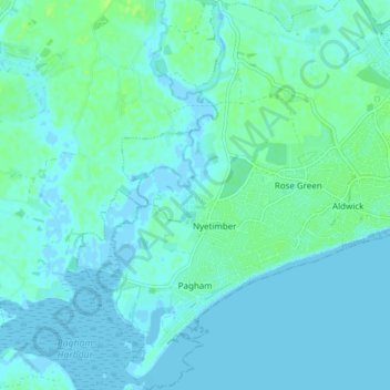
Name: Pagham topographic map, elevation, terrain.

Location: Pagham, Nyetimber, Arun, West Sussex, England, United Kingdom (50.75639 -0.76483 50.80945 -0.70367)

Average elevation: 3 m

Minimum elevation: -3 m

Maximum elevation: 10 m

Other topographic maps

Click on a map to view its topography, its elevation and its terrain.

Bognor Regis

United Kingdom > England > West Sussex > Arun > Nyetimber

Average elevation: 2 m

Nyetimber

United Kingdom > England > West Sussex > Arun

Average elevation: 3 m

Lidsey Rife

United Kingdom > England > West Sussex > Arun > Felpham

Average elevation: 3 m

Elmer

United Kingdom > England > West Sussex > Arun

Average elevation: 2 m

Wick

United Kingdom > England > West Sussex > Arun > Littlehampton > Lyminster

Average elevation: 3 m

Shripney

United Kingdom > England > West Sussex > Arun

Average elevation: 3 m

Fontwell

United Kingdom > England > West Sussex > Arun

Average elevation: 31 m

Eastergate

United Kingdom > England > West Sussex > Arun

Average elevation: 12 m

Barnham

United Kingdom > England > West Sussex > Arun

Average elevation: 6 m

North Bersted

United Kingdom > England > West Sussex > Arun

Average elevation: 3 m

Binsted

United Kingdom > England > West Sussex > Arun > Walberton

Average elevation: 23 m

Barnham

United Kingdom > England > West Sussex > Arun

Average elevation: 6 m

Eastergate

United Kingdom > England > West Sussex > Arun

Average elevation: 12 m

Gear up for your next adventure:

🗺️Topographic Maps - Detailed maps for hiking and navigation
🛠️Outdoor Repair Kits - Gear repair kits
🔥Ferrocerium Rod Fire Starters - Reliable fire lighting in wet or windy conditions without matches
🧼Biodegradable Outdoor Soap - Clean gear and yourself without harming the local ecosystem
🪢Paracord - Multi-purpose survival cord

As an Amazon Associate, this site earns from qualifying purchases at no extra cost to you.