
Otavalo topographic map
Interactive map
Click on the map to display elevation.
About this map
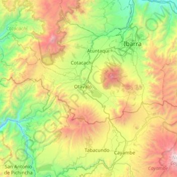
Name: Otavalo topographic map, elevation, terrain.
Location: Otavalo, Imbabura, Ecuador (0.12291 -78.62501 0.32262 -78.12019)
Average elevation: 2,875 m
Minimum elevation: 1,489 m
Maximum elevation: 5,519 m
Other topographic maps
Click on a map to view its topography, its elevation and its terrain.
González Suárez
Ecuador > Imbabura > Otavalo > González Suárez
González Suárez, Otavalo, Imbabura, 1986, Ecuador
Average elevation: 3,161 m