
Águeda topographic map
Interactive map
Click on the map to display elevation.
About this map
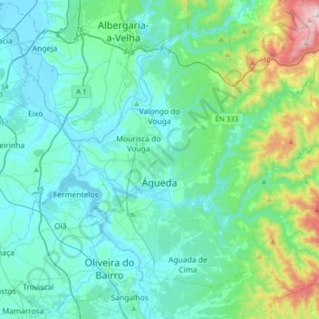
Name: Águeda topographic map, elevation, terrain.
Location: Águeda, Aveiro, Portugal (40.49591 -8.55815 40.69428 -8.24538)
Average elevation: 166 m
Minimum elevation: 0 m
Maximum elevation: 802 m
Other topographic maps
Click on a map to view its topography, its elevation and its terrain.
Branca
Portugal > Aveiro > Albergaria-a-Velha
Branca, Albergaria-a-Velha, Aveiro, Portugal
Average elevation: 140 m
Ul
Portugal > Aveiro > Oliveira de Azeméis
Ul, Oliveira de Azeméis, Aveiro, 3720-254, Portugal
Average elevation: 143 m
Cedrim
Portugal > Aveiro > Sever do Vouga
Cedrim, Sever do Vouga, Aveiro, 3740-070, Portugal
Average elevation: 261 m
Cedrim e Paradela
Portugal > Aveiro > Sever do Vouga
Cedrim e Paradela, Sever do Vouga, Aveiro, Portugal
Average elevation: 286 m