
Sriharikota topographic map
Interactive map
Click on the map to display elevation.
About this map
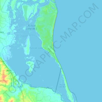
Name: Sriharikota topographic map, elevation, terrain.
Average elevation: 2 m
Minimum elevation: -7 m
Maximum elevation: 30 m
Sriharikota is partly located in Sullurpeta mandal and partly located in Tada mandal in Nellore district in Andhra Pradesh and separates Pulicat Lake from the Bay of Bengal The nearest town and railway station is Sullurpeta which is 16 km west of Sriharikota. A 16 km elevated road connects Sriharikota to the mainland. It is about 70 km north of Chennai city. It has elevation of 1 meter
Other topographic maps
Click on a map to view its topography, its elevation and its terrain.
Machilipatnam
India > Andhra Pradesh > Machilipatnam
Machilipatnam, Krishna, Andhra Pradesh, 521001, India
Average elevation: 4 m
Sullurpeta
India > Andhra Pradesh > Sullurpeta
Sullurpeta, Tirupati District, Andhra Pradesh, 524121, India
Average elevation: 4 m
Narsipatnam
Narsipatnam, Anakapalli, Andhra Pradesh, India
Average elevation: 92 m
Sarpavaram
India > Andhra Pradesh > Kakinada (Rural) > Sarpavaram
Sarpavaram, Kakinada (Rural), Kakinada, Andhra Pradesh, 533003, India
Average elevation: 6 m
Chennuru
India > Andhra Pradesh > Pedana > Chennuru
Chennuru, Pedana, Krishna, Andhra Pradesh, India
Average elevation: 4 m
Rajamahendravaram
India > Andhra Pradesh > Rajamahendravaram
Rajamahendravaram, Rajahmundry (Urban), East Godavari, Andhra Pradesh, 533100, India
Average elevation: 29 m
Nellore
India > Andhra Pradesh > Nellore
Nellore, Sri Potti Sriramulu Nellore, Andhra Pradesh, 524001, India
Average elevation: 17 m
Salamanda
India > Andhra Pradesh > Salamanda
Salamanda, Visakhapatnam, Andhra Pradesh, India
Average elevation: 1,131 m