
Isla San Lorenzo topographic map
Interactive map
Click on the map to display elevation.
About this map
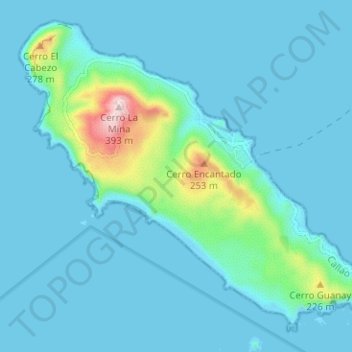
Name: Isla San Lorenzo topographic map, elevation, terrain.
Location: Isla San Lorenzo, Callao, Perú (-12.11363 -77.25155 -12.05904 -77.18865)
Average elevation: 44 m
Minimum elevation: 0 m
Maximum elevation: 393 m
Other topographic maps
Click on a map to view its topography, its elevation and its terrain.