Geolocate

Pasadena topographic map

Click on the map to display elevation.

About this map

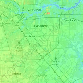
Name: Pasadena topographic map, elevation, terrain.

Location: Pasadena, Harris County, Texas, United States (29.55792 -95.23468 29.74024 -94.98264)

Average elevation: 11 m

Minimum elevation: -2 m

Maximum elevation: 42 m

Other topographic maps

Click on a map to view its topography, its elevation and its terrain.

Cypress

United States > Texas > Harris County

Average elevation: 46 m

Spring

United States > Texas > Harris County > Spring

Average elevation: 35 m

Gear up for your next adventure:

🔌Fast Charging Adapters - Quickly top up all your gear before heading back into the field
👣Snake & Scrub Gaiters - Protection against spinifex, mud, and snakes while walking off-track
Altimeter Watches - Watches with altitude tracking
🌬️Windbreaker Jackets - Wind protection jackets
🔑Heavy Duty Carabiners - Secure gear to the outside of your pack for easy access

As an Amazon Associate, this site earns from qualifying purchases at no extra cost to you.