Geolocate

Penguin topographic map

Click on the map to display elevation.

About this map

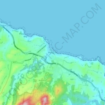
Name: Penguin topographic map, elevation, terrain.

Location: Penguin, Tasmania, 7316, Australia (-41.15510 146.03248 -41.07510 146.11248)

Average elevation: 58 m

Minimum elevation: -1 m

Maximum elevation: 445 m

Tasmania trails, hiking, mountain biking, running and outdoor activities

Gear up for your next adventure:

🪑Portable Backpacking Chairs - A comfortable seat for studying maps at the end of the day
GPS Watches - GPS watches for outdoor sports
🦘Outback Survival Gear - Essential gear for Australian outback
🧥Thermal Emergency Blankets - Compact Mylar blankets to prevent hypothermia if stranded overnight
🍴Titanium Spork & Cutlery - Indestructible and feather-light eating utensils

As an Amazon Associate, this site earns from qualifying purchases at no extra cost to you.