
Saint-Paul topographic map
Interactive map
Click on the map to display elevation.
About this map
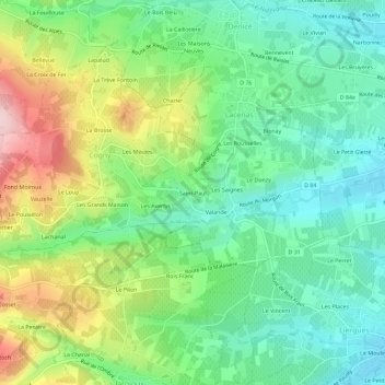
Name: Saint-Paul topographic map, elevation, terrain.
Average elevation: 313 m
Minimum elevation: 222 m
Maximum elevation: 487 m
Other topographic maps
Click on a map to view its topography, its elevation and its terrain.
Morgon
France > Auvergne-Rhône-Alpes > Rhône > Lacenas
Morgon, Lacenas, Villefranche-sur-Saône, Rhône, Auvergne-Rhône-Alpes, France métropolitaine, 69640, France
Average elevation: 298 m
Les Rousselles
France > Auvergne-Rhône-Alpes > Rhône > Lacenas
Les Rousselles, Lacenas, Villefranche-sur-Saône, Rhône, Auvergne-Rhône-Alpes, France métropolitaine, 69640, France
Average elevation: 296 m