
Thank you for supporting this site ❤️
Make a donation
Make a donation
Gear up for your next adventure:
As an Amazon Associate, this site earns from qualifying purchases at no extra cost to you.
Garmal topographic map
Click on the map to display elevation.
Thank you for supporting this site ❤️
Make a donation
Make a donation
Gear up for your next adventure:
As an Amazon Associate, this site earns from qualifying purchases at no extra cost to you.
About this map
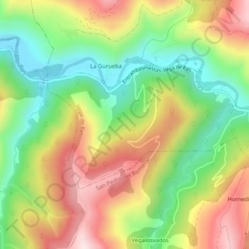
Name: Garmal topographic map, elevation, terrain.
Location: Garmal, Vega de Pas, Valles Pasiegos, Cantabria, 39683, Spain (43.15218 -3.85562 43.17218 -3.83562)
Average elevation: 439 m
Minimum elevation: 235 m
Maximum elevation: 683 m
Thank you for supporting this site ❤️
Make a donation
Make a donation
Gear up for your next adventure:
As an Amazon Associate, this site earns from qualifying purchases at no extra cost to you.