
Make a donation
Gear up for your next adventure:
As an Amazon Associate, this site earns from qualifying purchases at no extra cost to you.
Ruhpolding topographic map
Click on the map to display elevation.
Make a donation
Gear up for your next adventure:
As an Amazon Associate, this site earns from qualifying purchases at no extra cost to you.
About this map
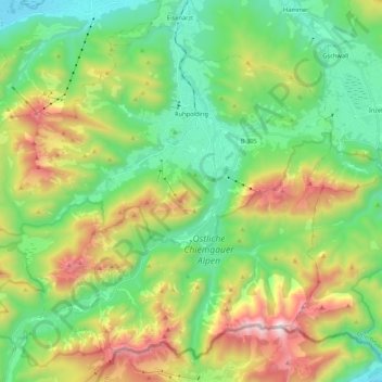
Name: Ruhpolding topographic map, elevation, terrain.
Location: Ruhpolding, Landkreis Traunstein, Bavaria, 83324, Germany (47.67012 12.51204 47.79567 12.72504)
Average elevation: 988 m
Minimum elevation: 521 m
Maximum elevation: 1,927 m
Make a donation
Gear up for your next adventure:
As an Amazon Associate, this site earns from qualifying purchases at no extra cost to you.
Other topographic maps
Click on a map to view its topography, its elevation and its terrain.
Waginger See
Germany > Bavaria > Landkreis Traunstein > Waginger See > Fisching
Waginger See is a lake in the Alpine foothills, Bavaria, Germany. Geologically, it forms one single lake with the Tachinger See, with which it is connected through a narrow strait at Tettenhausen. The surface area of the Waginger See proper is 6.61 km2 (2.55 sq mi); combined with the Tachinger See it is 8.97…
Average elevation: 464 m
Make a donation
Gear up for your next adventure:
As an Amazon Associate, this site earns from qualifying purchases at no extra cost to you.
St. Georgen
Germany > Bavaria > Landkreis Traunstein > Traunreut > St. Georgen
Average elevation: 541 m
Make a donation
Gear up for your next adventure:
As an Amazon Associate, this site earns from qualifying purchases at no extra cost to you.