
Garfield Heights topographic map
Interactive map
Click on the map to display elevation.
Garfield Heights
According to the United States Census Bureau, the city has a total area of 7.29 square miles (18.88 km2), of which 7.23 square miles (18.73 km2) is land and 0.06 square miles (0.16 km2) is water. The elevation of Garfield Heights is 831 feet (253 m) above sea level where it borders Cleveland, and its highest elevation is 972 feet (296 m) above sea level at the Garfield Heights Justice Center.
About this map
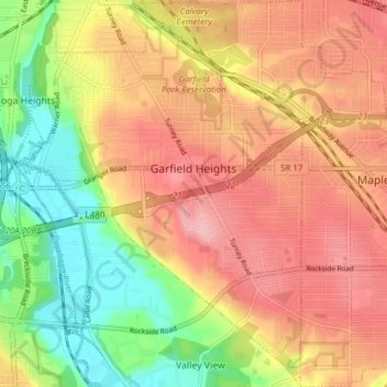
Name: Garfield Heights topographic map, elevation, terrain.
Average elevation: 251 m
Minimum elevation: 178 m
Maximum elevation: 308 m
Other topographic maps
Click on a map to view its topography, its elevation and its terrain.
Cleveland
United States > Ohio > Cuyahoga County > Cleveland
The land rises quickly from the lake shore elevation of 569 feet. Public Square, less than one mile (1.6 km) inland, sits at an elevation of 650 feet (198 m), and Hopkins Airport, 5 miles (8 km) inland from the lake, is at an elevation of 791 feet (241 m).
Average elevation: 219 m