Geolocate

Milton topographic map

Click on the map to display elevation.

About this map

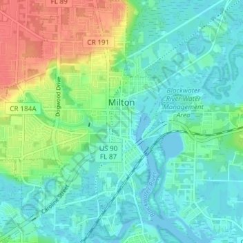
Name: Milton topographic map, elevation, terrain.

Location: Milton, Santa Rosa County, Florida, 32572, United States (30.60225 -87.07743 30.65440 -87.02938)

Average elevation: 15 m

Minimum elevation: -3 m

Maximum elevation: 51 m

Other topographic maps

Click on a map to view its topography, its elevation and its terrain.

Milton

United States > Florida > Santa Rosa County > Milton > Milton

Average elevation: 21 m

Gear up for your next adventure:

📣High-Decibel Survival Whistles - Signaling tool for rescue that carries much further than a human voice
🏫Topographic World Globes - 3D physical relief globes to understand global geography
🔥Camping Stoves - Portable stoves for outdoor cooking
📱Tablet Tripod Mounts - Steady platforms for viewing digital maps or taking long exposures
📱Shockproof Phone Cases - Extra protection for your smartphone against drops on rocky terrain

As an Amazon Associate, this site earns from qualifying purchases at no extra cost to you.