Geolocate

Ashmore topographic map

Click on the map to display elevation.

About this map

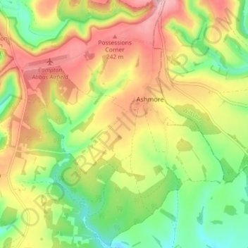
Name: Ashmore topographic map, elevation, terrain.

Location: Ashmore, Dorset, England, United Kingdom (50.93292 -2.16066 50.97821 -2.10266)

Average elevation: 180 m

Minimum elevation: 101 m

Maximum elevation: 266 m

Gear up for your next adventure:

🦟Insect Repellent - Protection against insects
🧯Animal Deterrent Spray - Safety spray for wildlife
🪑Portable Backpacking Chairs - A comfortable seat for studying maps at the end of the day
🧴SPF 50+ Bulk Sunscreen - Maximum protection for long-term outdoor exposure
🎒Tactical Waist Packs - Quick access to your compass, phone, and snacks while walking

As an Amazon Associate, this site earns from qualifying purchases at no extra cost to you.