
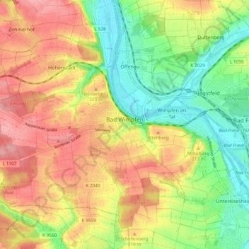
Bad Wimpfen topographic map
Interactive map
Click on the map to display elevation.
About this map
Name: Bad Wimpfen topographic map, elevation, terrain.
Average elevation: 199 m
Minimum elevation: 143 m
Maximum elevation: 256 m
Other topographic maps
Click on a map to view its topography, its elevation and its terrain.
Ittlingen
Allemagne > Bade-Wurtemberg > Landkreis Heilbronn
Ittlingen, Verwaltungsgemeinschaft Eppingen, Landkreis Heilbronn, Bade-Wurtemberg, 74930, Allemagne
Average elevation: 223 m
Abstatt
Allemagne > Bade-Wurtemberg > Landkreis Heilbronn
Abstatt, Verwaltungsverband Schozach-Bottwartal, Landkreis Heilbronn, Bade-Wurtemberg, 74232, Allemagne
Average elevation: 277 m