
Make a donation
Gear up for your next adventure:
As an Amazon Associate, this site earns from qualifying purchases at no extra cost to you.
Unteregg topographic map
Click on the map to display elevation.
Make a donation
Gear up for your next adventure:
As an Amazon Associate, this site earns from qualifying purchases at no extra cost to you.
Unteregg
Am 30. Juni 2018 gab es in der Gemeinde 136 sozialversicherungspflichtige Arbeitsplätze; von der Wohnbevölkerung standen 572 Personen in einer versicherungspflichtigen Beschäftigung, so dass die Zahl der Auspendler um 436 höher war. Die 52 landwirtschaftlichen Betriebe bewirtschafteten eine Fläche von 1482 Hektar (Stand 2016).
Make a donation
Gear up for your next adventure:
As an Amazon Associate, this site earns from qualifying purchases at no extra cost to you.
About this map
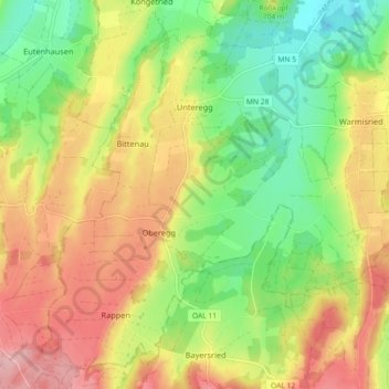
Name: Unteregg topographic map, elevation, terrain.
Average elevation: 704 m
Minimum elevation: 632 m
Maximum elevation: 784 m
Make a donation
Gear up for your next adventure:
As an Amazon Associate, this site earns from qualifying purchases at no extra cost to you.
Other topographic maps
Click on a map to view its topography, its elevation and its terrain.
Bollenmühle
Deutschland > Bayern > Landkreis Unterallgäu > Ottobeuren > Ollarzried
Average elevation: 767 m
Herbisried
Deutschland > Bayern > Landkreis Unterallgäu > Bad Grönenbach
Herbisried liegt in Oberschwaben in der Donau-Iller-Region, etwa drei Kilometer südlich von Bad Grönenbach, auf einer Höhe von 769 m ü. NN. An Herbisried grenzen im Uhrzeigersinn, im Norden beginnend, der Markt Bad Grönenbach, die Weiler Kornhofen, Hueb, Gmeinschwenden, Sommersberg und Greit. Mit Ausnahme…
Average elevation: 731 m
Make a donation
Gear up for your next adventure:
As an Amazon Associate, this site earns from qualifying purchases at no extra cost to you.
Make a donation
Gear up for your next adventure:
As an Amazon Associate, this site earns from qualifying purchases at no extra cost to you.
Guggenberg
Deutschland > Bayern > Landkreis Unterallgäu > Ottobeuren
Ottobeuren | Bäuerle | Betzisried | Bibelsberg | Böglins | Boschach | Brüchlins | Bühl | Daßberg | Dennenberg | Eggisried | Eheim | Eheimer Mühle | Eldern | Fröhlins | Geislins | Guggenberg | Gumpratsried | Gut | Hahnenbühl | Haitzen | Halbersberg | Hessen | Höhe | Hofs | Kloster Wald | Langenberg |…
Average elevation: 696 m
Make a donation
Gear up for your next adventure:
As an Amazon Associate, this site earns from qualifying purchases at no extra cost to you.
Halbersberg
Deutschland > Bayern > Landkreis Unterallgäu > Ottobeuren > Langenberg
Ottobeuren | Bäuerle | Betzisried | Bibelsberg | Böglins | Boschach | Brüchlins | Bühl | Daßberg | Dennenberg | Eggisried | Eheim | Eheimer Mühle | Eldern | Fröhlins | Geislins | Guggenberg | Gumpratsried | Gut | Hahnenbühl | Haitzen | Halbersberg | Hessen | Höhe | Hofs | Kloster Wald | Langenberg |…
Average elevation: 692 m
Make a donation
Gear up for your next adventure:
As an Amazon Associate, this site earns from qualifying purchases at no extra cost to you.
Brüchlins
Deutschland > Bayern > Landkreis Unterallgäu > Ottobeuren
Ottobeuren | Bäuerle | Betzisried | Bibelsberg | Böglins | Boschach | Brüchlins | Bühl | Daßberg | Dennenberg | Eggisried | Eheim | Eheimer Mühle | Eldern | Fröhlins | Geislins | Guggenberg | Gumpratsried | Gut | Hahnenbühl | Haitzen | Halbersberg | Hessen | Höhe | Hofs | Kloster Wald | Langenberg |…
Average elevation: 677 m
Make a donation
Gear up for your next adventure:
As an Amazon Associate, this site earns from qualifying purchases at no extra cost to you.
Make a donation
Gear up for your next adventure:
As an Amazon Associate, this site earns from qualifying purchases at no extra cost to you.
Gmeinschwenden
Deutschland > Bayern > Landkreis Unterallgäu > Bad Grönenbach
Das Dorf liegt etwa drei Kilometer südlich von Bad Grönenbach auf einer Höhe von 750 m ü. NN. Die Landkreisgrenze zwischen Unterallgäu und Oberallgäu verläuft unmittelbar südlich des Dorfes. Gmeinschwenden grenzt im Norden an das Dorf Herbisried, sowie im weiteren Verlauf im Uhrzeigersinn an die Weiler…
Average elevation: 726 m
Make a donation
Gear up for your next adventure:
As an Amazon Associate, this site earns from qualifying purchases at no extra cost to you.
Make a donation
Gear up for your next adventure:
As an Amazon Associate, this site earns from qualifying purchases at no extra cost to you.
Schlingen
Deutschland > Bayern > Landkreis Unterallgäu > Bad Wörishofen
Das Pfarrdorf Schlingen liegt westlich der Wertach auf einer Höhe von 642 m ü. NHN, umfasst ein Gebiet von rund 13,37 Quadratkilometer und hatte im Dezember 2021 746 Einwohner.
Average elevation: 645 m
Make a donation
Gear up for your next adventure:
As an Amazon Associate, this site earns from qualifying purchases at no extra cost to you.
Dietratried
Deutschland > Bayern > Landkreis Unterallgäu
Das Kirchdorf Dietratried liegt drei Kilometer nordwestlich von Wolfertschwenden, auf einer Höhe von 651 m ü. NN.
Average elevation: 680 m
Make a donation
Gear up for your next adventure:
As an Amazon Associate, this site earns from qualifying purchases at no extra cost to you.
Stockheim
Deutschland > Bayern > Landkreis Unterallgäu > Bad Wörishofen > Stockheim
Average elevation: 629 m
Griesthal
Deutschland > Bayern > Landkreis Unterallgäu > Markt Rettenbach > Griesthal
Average elevation: 759 m
Make a donation
Gear up for your next adventure:
As an Amazon Associate, this site earns from qualifying purchases at no extra cost to you.
Make a donation
Gear up for your next adventure:
As an Amazon Associate, this site earns from qualifying purchases at no extra cost to you.
Make a donation
Gear up for your next adventure:
As an Amazon Associate, this site earns from qualifying purchases at no extra cost to you.