
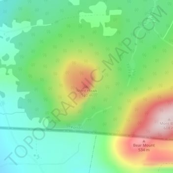
Mont Hawk topographic map
Interactive map
Click on the map to display elevation.
About this map
Name: Mont Hawk topographic map, elevation, terrain.
Location: Mont Hawk, Potton, Memphrémagog, Estrie, Québec, Canada (45.01199 -72.33145 45.01209 -72.33135)
Average elevation: 345 m
Minimum elevation: 207 m
Maximum elevation: 595 m
Other topographic maps
Click on a map to view its topography, its elevation and its terrain.
Mont Éléphant
Mont Éléphant, Potton, Memphrémagog, Estrie, Québec, Canada
Average elevation: 389 m
Mont Sugar Loaf
Mont Sugar Loaf, Potton, Memphrémagog, Estrie, Québec, Canada
Average elevation: 401 m
Lac Memphrémagog
Lac Memphrémagog, Chemin du Quai, Potton, Memphrémagog, Estrie, Québec, Canada
Average elevation: 209 m
Mont Owl's Head
Mont Owl's Head, Potton, Memphrémagog, Estrie, Québec, Canada
Average elevation: 370 m