
Hoke County topographic map
Interactive map
Click on the map to display elevation.
About this map
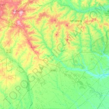
Name: Hoke County topographic map, elevation, terrain.
Location: Hoke County, North Carolina, VS (34.83556 -79.45920 35.21102 -79.03660)
Average elevation: 87 m
Minimum elevation: 34 m
Maximum elevation: 189 m
Other topographic maps
Click on a map to view its topography, its elevation and its terrain.
Buies Creek
VS > North Carolina > Buies Creek
Buies Creek, Harnett County, North Carolina, 27506, VS
Average elevation: 61 m
Mount Mitchell
Mount Mitchell, Yancey County, North Carolina, VS
Average elevation: 1,743 m