
Xi Jiang topographic map
Interactive map
Click on the map to display elevation.
About this map
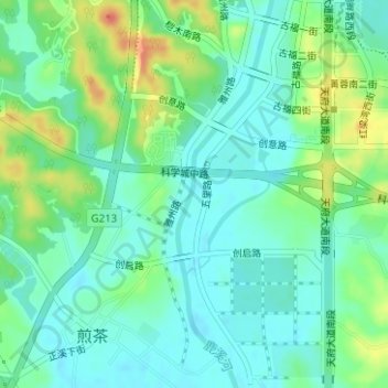
Name: Xi Jiang topographic map, elevation, terrain.
Location: Xi Jiang, 天府新区成都直管区, 双流区 / Shuangliu, 成都市, Sichuan, China (30.38211 104.05776 30.39391 104.06225)
Average elevation: 468 m
Minimum elevation: 452 m
Maximum elevation: 503 m
Other topographic maps
Click on a map to view its topography, its elevation and its terrain.
松潘县 ཟུང་ཆུ་རྫོང།
松潘县 ཟུང་ཆུ་རྫོང།, Autonome Tibetaanse & Qiang Prefectuur Ngawa, Sichuan, 623300, China
Average elevation: 3,301 m