
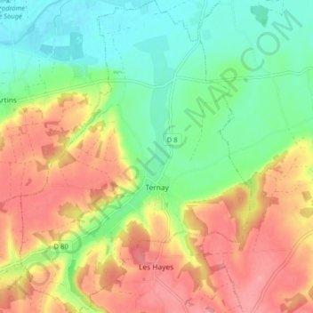
Ternay topographic map
Interactive map
Click on the map to display elevation.
About this map
Name: Ternay topographic map, elevation, terrain.
Average elevation: 99 m
Minimum elevation: 57 m
Maximum elevation: 147 m
L'altitude du territoire communal varie de 59 mètres à 139 mètres.
Other topographic maps
Click on a map to view its topography, its elevation and its terrain.
Thenay
France > Centre-Val de Loire > Loir-et-Cher > Le Controis-en-Sologne
Thenay, Le Controis-en-Sologne, Romorantin-Lanthenay, Loir-et-Cher, Centre-Val de Loire, France métropolitaine, 41400, France
Average elevation: 104 m
Vendôme
France > Centre-Val de Loire > Loir-et-Cher
Vendôme, Loir-et-Cher, Centre-Val de Loire, France métropolitaine, 41100, France
Average elevation: 110 m
Blois
France > Centre-Val de Loire > Loir-et-Cher
Blois, Loir-et-Cher, Centre-Val de Loire, France métropolitaine, 41000, France
Average elevation: 95 m