
Ankang City topographic map
Interactive map
Click on the map to display elevation.
About this map
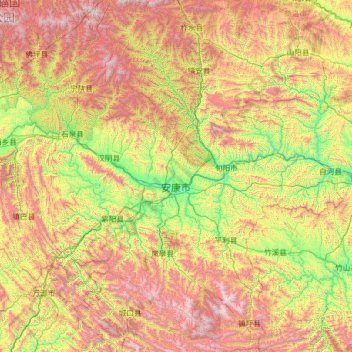
Name: Ankang City topographic map, elevation, terrain.
Location: Ankang City, Shaanxi, 725100, China (31.70667 108.01660 33.84169 110.20130)
Average elevation: 1,071 m
Minimum elevation: 184 m
Maximum elevation: 2,856 m
Other topographic maps
Click on a map to view its topography, its elevation and its terrain.
Hanbin District
China > Shaanxi > Ankang City
Hanbin District, Ankang City, Shaanxi, China
Average elevation: 814 m
Mian County
China > Shaanxi > Mian County
Mian County, Hanzhong City, Shaanxi, China
Average elevation: 1,161 m