
Sterrebeek topographic map
Interactive map
Click on the map to display elevation.
About this map
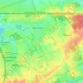
Name: Sterrebeek topographic map, elevation, terrain.
Average elevation: 72 m
Minimum elevation: 42 m
Maximum elevation: 111 m
Other topographic maps
Click on a map to view its topography, its elevation and its terrain.
Nossegem
België > Vlaams-Brabant > Halle-Vilvoorde > Zaventem
Nossegem, Zaventem, Halle-Vilvoorde, Vlaams-Brabant, België
Average elevation: 57 m
Sint-Stevens-Woluwe
België > Vlaams-Brabant > Halle-Vilvoorde > Zaventem
Sint-Stevens-Woluwe, Zaventem, Halle-Vilvoorde, Vlaams-Brabant, 1932, België
Average elevation: 59 m