
Ragunda kommun topographic map
Interactive map
Click on the map to display elevation.
About this map
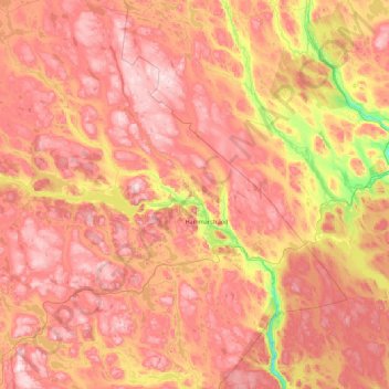
Name: Ragunda kommun topographic map, elevation, terrain.
Location: Ragunda kommun, Jämtland County, Sweden (62.80849 15.22126 63.51481 16.99870)
Average elevation: 315 m
Minimum elevation: 25 m
Maximum elevation: 571 m
Other topographic maps
Click on a map to view its topography, its elevation and its terrain.
Lofsdalen
Lofsdalen, Härjedalens kommun, Jämtland County, 840 85, Sweden
Average elevation: 672 m
Lillhärdal
Lillhärdal, Lillhärdal distrikt, Härjedalens kommun, Jämtland County, Sweden
Average elevation: 459 m
Östersund
Östersund, Östersunds kommun, Jämtland County, 831 86, Sweden
Average elevation: 341 m
Lill-Rånddalen
Lill-Rånddalen, Sörhålla Vägen, Härjedalens kommun, Jämtland County, Sweden
Average elevation: 605 m