
Namalpalan topographic map
Interactive map
Click on the map to display elevation.
About this map
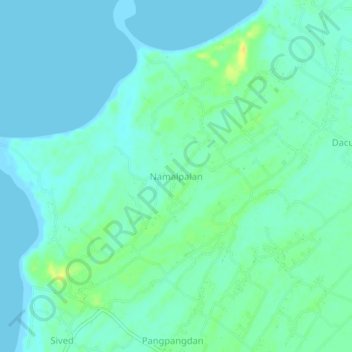
Name: Namalpalan topographic map, elevation, terrain.
Location: Namalpalan, Ilocos Sur, Ilocos Region, 2730, Philippines (17.65793 120.36708 17.69793 120.40708)
Average elevation: 7 m
Minimum elevation: -2 m
Maximum elevation: 24 m
Other topographic maps
Click on a map to view its topography, its elevation and its terrain.
Vigan
Vigan, Ilocos Sur, Ilocos Region, 2700, Philippines
Average elevation: 34 m
San Juan
Philippines > Ilocos Sur > San Juan
San Juan, Ilocos Sur, Ilocos Region, 2731, Philippines
Average elevation: 37 m
Barangobong
Philippines > Ilocos Sur > Santa Lucia > Barangobong
Barangobong, Santa Lucia, Ilocos Sur, Ilocos Region, 2713, Philippines
Average elevation: 10 m