Geolocate

Trabzon topographic map

Click on the map to display elevation.

About this map
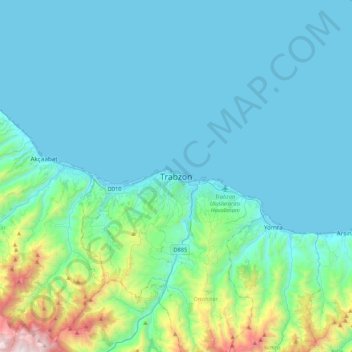
Name: Trabzon topographic map, elevation, terrain.

Location: Trabzon, Ortahisar, Trabzon, Black Sea Region, 61050, Turkey (40.84546 39.57015 41.16546 39.89015)

Average elevation: 241 m

Minimum elevation: 0 m

Maximum elevation: 1,863 m

Other topographic maps

Click on a map to view its topography, its elevation and its terrain.

Fatih Parkı

Turkey > Ortahisar

Average elevation: 60 m

Hızırbey Mahallesi

Turkey > Ortahisar

Average elevation: 28 m

Gülbaharhatun Mahallesi

Turkey > Ortahisar

Average elevation: 65 m

Gear up for your next adventure:

🔋Solar Power Banks - Charge your phone and GPS using the sun while deep in the bush
🧼Clip-on Hand Sanitizer - Maintain hygiene when water for washing is scarce
🎧Bluetooth Outdoor Earbuds - Listen to navigation cues or podcasts during long solo treks
🪢Paracord - Multi-purpose survival cord
🔥Ferrocerium Rod Fire Starters - Reliable fire lighting in wet or windy conditions without matches

As an Amazon Associate, this site earns from qualifying purchases at no extra cost to you.