
Make a donation
Gear up for your next adventure:
As an Amazon Associate, this site earns from qualifying purchases at no extra cost to you.
Travedona Monate topographic map
Click on the map to display elevation.
Make a donation
Gear up for your next adventure:
As an Amazon Associate, this site earns from qualifying purchases at no extra cost to you.
About this map
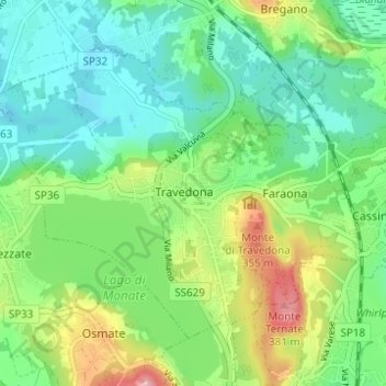
Name: Travedona Monate topographic map, elevation, terrain.
Location: Travedona Monate, Varese, Lombardy, 21028, Italy (45.78829 8.63944 45.82082 8.70107)
Average elevation: 264 m
Minimum elevation: 211 m
Maximum elevation: 383 m
Make a donation
Gear up for your next adventure:
As an Amazon Associate, this site earns from qualifying purchases at no extra cost to you.
Other topographic maps
Click on a map to view its topography, its elevation and its terrain.
Castendallo
Italy > Lombardy > Varese > Montegrino Valtravaglia > Bosco Valtravaglia
Average elevation: 491 m
Make a donation
Gear up for your next adventure:
As an Amazon Associate, this site earns from qualifying purchases at no extra cost to you.
Make a donation
Gear up for your next adventure:
As an Amazon Associate, this site earns from qualifying purchases at no extra cost to you.