
Make a donation
Gear up for your next adventure:
As an Amazon Associate, this site earns from qualifying purchases at no extra cost to you.
Kimpton topographic map
Click on the map to display elevation.
Make a donation
Gear up for your next adventure:
As an Amazon Associate, this site earns from qualifying purchases at no extra cost to you.
About this map
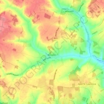
Name: Kimpton topographic map, elevation, terrain.
Average elevation: 120 m
Minimum elevation: 76 m
Maximum elevation: 156 m
Make a donation
Gear up for your next adventure:
As an Amazon Associate, this site earns from qualifying purchases at no extra cost to you.
Other topographic maps
Click on a map to view its topography, its elevation and its terrain.
Letchworth
United Kingdom > England > Hertfordshire > North Hertfordshire > Letchworth
Average elevation: 80 m
Make a donation
Gear up for your next adventure:
As an Amazon Associate, this site earns from qualifying purchases at no extra cost to you.
Ashbrook
United Kingdom > England > Hertfordshire > North Hertfordshire > St Ippolyts
Average elevation: 85 m
Windmill Hill
United Kingdom > England > Hertfordshire > North Hertfordshire > Hitchin
Average elevation: 74 m
Temple Dinsley
United Kingdom > England > Hertfordshire > North Hertfordshire > Preston
Average elevation: 124 m
Make a donation
Gear up for your next adventure:
As an Amazon Associate, this site earns from qualifying purchases at no extra cost to you.
Bendish
United Kingdom > England > Hertfordshire > North Hertfordshire > Breachwood Green
Average elevation: 128 m
Knebworth Country Park
United Kingdom > England > Hertfordshire > North Hertfordshire > Knebworth
Average elevation: 116 m
Great Wymondley
United Kingdom > England > Hertfordshire > North Hertfordshire
Average elevation: 87 m
Make a donation
Gear up for your next adventure:
As an Amazon Associate, this site earns from qualifying purchases at no extra cost to you.
Peter's Green
United Kingdom > England > Hertfordshire > North Hertfordshire > Kimpton
Average elevation: 133 m
Ivel Springs Local Nature Reserve
United Kingdom > England > Hertfordshire > North Hertfordshire > Baldock
Average elevation: 72 m
Cockernhoe
United Kingdom > England > Hertfordshire > North Hertfordshire > Offley > Cockernhoe
Average elevation: 149 m
Little Wymondley
United Kingdom > England > Hertfordshire > North Hertfordshire
Average elevation: 92 m
Make a donation
Gear up for your next adventure:
As an Amazon Associate, this site earns from qualifying purchases at no extra cost to you.
Offley Hoo
United Kingdom > England > Hertfordshire > North Hertfordshire > Offley
Average elevation: 134 m
Long Pond
United Kingdom > England > Hertfordshire > North Hertfordshire > Offley > Offley Hoo
Average elevation: 142 m
Knebworth Country Park
United Kingdom > England > Hertfordshire > North Hertfordshire > Knebworth
Average elevation: 116 m
Make a donation
Gear up for your next adventure:
As an Amazon Associate, this site earns from qualifying purchases at no extra cost to you.