
Niendorf/Ostsee topographic map
Interactive map
Click on the map to display elevation.
About this map
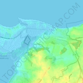
Name: Niendorf/Ostsee topographic map, elevation, terrain.
Average elevation: 6 m
Minimum elevation: -5 m
Maximum elevation: 24 m
Other topographic maps
Click on a map to view its topography, its elevation and its terrain.
Timmendorfer Strand
Deutschland > Schleswig-Holstein > Ostholstein > Timmendorfer Strand
Timmendorfer Strand, Ostholstein, Schleswig-Holstein, 23669, Deutschland
Average elevation: 9 m
Hemmelsdorf
Deutschland > Schleswig-Holstein > Ostholstein > Timmendorfer Strand
Hemmelsdorf, Timmendorfer Strand, Ostholstein, Schleswig-Holstein, Deutschland
Average elevation: 11 m