
Make a donation
Gear up for your next adventure:
As an Amazon Associate, this site earns from qualifying purchases at no extra cost to you.
Taplejung topographic map
Click on the map to display elevation.
Make a donation
Gear up for your next adventure:
As an Amazon Associate, this site earns from qualifying purchases at no extra cost to you.
Taplejung
Geographically Taplejung is a mountainous district located near to the world's third highest peak Kanchenjunga (8586 m). It is situated at elevation ranging from 670 metres (2,200 ft) to 8,586 metres (28,169 ft) from sea level. Tamur River is a main river in the district, which flows through the middle in the district dividing district in east and west Taplejung. Gunsa river, Simbuwa river and there are many tributaries of tamor are important source of freshwater. There are over than 60 rivers and streams in the district. Some glacial lakes are: Sinjenma Pokhari, Samdo Pokhari, Tin Pokhari, Kali Pokhari etc. The district includes many highest peaks eg. Gimmigela (7350 m), talung (7349 m), Kabru (7276 m), Nepal peak (7177 m), Kumbhkarna (7025 m) etc. Kanchenjunga Conservation Area is a protected area in the district which covers an area of 2,035 square kilometres (786 sq mi).
Make a donation
Gear up for your next adventure:
As an Amazon Associate, this site earns from qualifying purchases at no extra cost to you.
About this map
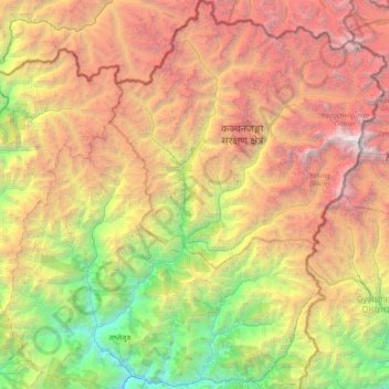
Name: Taplejung topographic map, elevation, terrain.
Location: Taplejung, Province #1, Nepal (27.26831 87.44430 27.95305 88.20153)
Average elevation: 3,894 m
Minimum elevation: 568 m
Maximum elevation: 8,521 m
Make a donation
Gear up for your next adventure:
As an Amazon Associate, this site earns from qualifying purchases at no extra cost to you.