
Zarqa topographic map
Click on the map to display elevation.
Zarqa
Zarqa has a cold semi-arid climate (Köppen climate classification: BSk). The average annual temperature is 17.4 °C (63.3 °F), and around 182 mm (7.17 in) of precipitation falls annually, mostly in winter months. Zarqa's elevation is 619 meters above sea level.
About this map
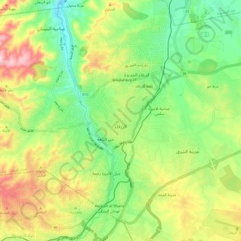
Name: Zarqa topographic map, elevation, terrain.
Location: Zarqa, Zarqa Sub-District, Zarqa Qasabah, Zarqa, Jordan (32.01972 36.01747 32.11856 36.13389)
Average elevation: 617 m
Minimum elevation: 491 m
Maximum elevation: 807 m
Other topographic maps
Click on a map to view its topography, its elevation and its terrain.