
Ramberg topographic map
Interactive map
Click on the map to display elevation.
About this map
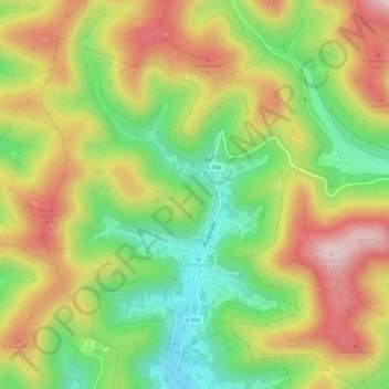
Name: Ramberg topographic map, elevation, terrain.
Average elevation: 409 m
Minimum elevation: 205 m
Maximum elevation: 635 m
Die Ortsgemeinde Ramberg liegt im Pfälzerwald rund sieben Kilometer Luftlinie nordnordöstlich von Annweiler am Trifels in dem nach ihr benannten Ramberger Tal. Wenige hundert Meter nördlich der Wohnbebauung des Ortes beginnt das Holpertal; weiter westlich von diesem liegt das Nonnental. Der Nordosten der Gemarkung reicht bis an das Modenbachtal heran. Die Passhöhe Drei Buchen bildet den Übergang zwischen dem Ramberger Tal und dem Modenbachtal. Zur Gemeinde gehört zudem der Modenbacherhof. Nachbargemeinden sind – im Uhrzeigersinn – Roschbach, Edesheim, Rhodt unter Rietburg, Weyher in der Pfalz, Hainfeld, Burrweiler, Flemlingen, Dernbach, Böchingen und Walsheim.
Other topographic maps
Click on a map to view its topography, its elevation and its terrain.
Insheim
Deutschland > Rheinland-Pfalz > Landkreis Südliche Weinstraße
Insheim, Herxheim, Landkreis Südliche Weinstraße, Rheinland-Pfalz, Deutschland
Average elevation: 145 m
Böchingen
Deutschland > Rheinland-Pfalz > Landkreis Südliche Weinstraße
Böchingen, Landau-Land, Landkreis Südliche Weinstraße, Rheinland-Pfalz, Deutschland
Average elevation: 263 m
Waldhambach
Deutschland > Rheinland-Pfalz > Landkreis Südliche Weinstraße
Waldhambach, Annweiler am Trifels, Landkreis Südliche Weinstraße, Rheinland-Pfalz, Deutschland
Average elevation: 315 m
Dierbach
Deutschland > Rheinland-Pfalz > Landkreis Südliche Weinstraße
Dierbach, Bad Bergzabern, Landkreis Südliche Weinstraße, Rheinland-Pfalz, Deutschland
Average elevation: 163 m
Bad Bergzabern
Deutschland > Rheinland-Pfalz > Landkreis Südliche Weinstraße
Bad Bergzabern, Landkreis Südliche Weinstraße, Rheinland-Pfalz, 76887, Deutschland
Average elevation: 238 m
Oberhausen
Deutschland > Rheinland-Pfalz > Landkreis Südliche Weinstraße
Oberhausen, Bad Bergzabern, Landkreis Südliche Weinstraße, Rheinland-Pfalz, Deutschland
Average elevation: 163 m
Annweiler am Trifels
Deutschland > Rheinland-Pfalz > Landkreis Südliche Weinstraße
Annweiler am Trifels, Landkreis Südliche Weinstraße, Rheinland-Pfalz, Deutschland
Average elevation: 339 m
Madenburg
Deutschland > Rheinland-Pfalz > Landkreis Südliche Weinstraße > Waldhambach
Madenburg, B 48, Waldhambach, Annweiler am Trifels, Landkreis Südliche Weinstraße, Rheinland-Pfalz, 76857, Deutschland
Average elevation: 290 m
Edenkoben
Deutschland > Rheinland-Pfalz > Landkreis Südliche Weinstraße
Edenkoben, Landkreis Südliche Weinstraße, Rheinland-Pfalz, 67480, Deutschland
Average elevation: 250 m
Billigheim-Ingenheim
Deutschland > Rheinland-Pfalz > Landkreis Südliche Weinstraße
Billigheim-Ingenheim, Landau-Land, Landkreis Südliche Weinstraße, Rheinland-Pfalz, 76831, Deutschland
Average elevation: 158 m
Billigheim
Deutschland > Rheinland-Pfalz > Landkreis Südliche Weinstraße
Billigheim, Billigheim-Ingenheim, Landau-Land, Landkreis Südliche Weinstraße, Rheinland-Pfalz, 76831, Deutschland
Average elevation: 158 m
Großfischlingen
Deutschland > Rheinland-Pfalz > Landkreis Südliche Weinstraße
Großfischlingen, Edenkoben, Landkreis Südliche Weinstraße, Rheinland-Pfalz, Deutschland
Average elevation: 136 m
Göcklingen
Deutschland > Rheinland-Pfalz > Landkreis Südliche Weinstraße
Göcklingen, Landau-Land, Landkreis Südliche Weinstraße, Rheinland-Pfalz, Deutschland
Average elevation: 205 m
Herxheim
Deutschland > Rheinland-Pfalz > Landkreis Südliche Weinstraße
Herxheim, Landkreis Südliche Weinstraße, Rheinland-Pfalz, 76863, Deutschland
Average elevation: 130 m
Schweighofen
Deutschland > Rheinland-Pfalz > Landkreis Südliche Weinstraße
Schweighofen, Bad Bergzabern, Landkreis Südliche Weinstraße, Rheinland-Pfalz, Deutschland
Average elevation: 164 m
Burrweiler
Deutschland > Rheinland-Pfalz > Landkreis Südliche Weinstraße
Burrweiler, Edenkoben, Landkreis Südliche Weinstraße, Rheinland-Pfalz, Deutschland
Average elevation: 327 m
Sankt Martin
Deutschland > Rheinland-Pfalz > Landkreis Südliche Weinstraße
Sankt Martin, Maikammer, Landkreis Südliche Weinstraße, Rheinland-Pfalz, Deutschland
Average elevation: 314 m
Heuchelheim
Deutschland > Rheinland-Pfalz > Landkreis Südliche Weinstraße
Heuchelheim, Heuchelheim-Klingen, Landau-Land, Landkreis Südliche Weinstraße, Rheinland-Pfalz, 76831, Deutschland
Average elevation: 187 m
Dörrenbach
Deutschland > Rheinland-Pfalz > Landkreis Südliche Weinstraße
Dörrenbach, Bad Bergzabern, Landkreis Südliche Weinstraße, Rheinland-Pfalz, Deutschland
Average elevation: 280 m
Sankt Martin
Deutschland > Rheinland-Pfalz > Landkreis Südliche Weinstraße > Sankt Martin > Sankt Martin
Sankt Martin, Maikammer, Landkreis Südliche Weinstraße, Rheinland-Pfalz, 67487, Deutschland
Average elevation: 308 m
Waldrohrbach
Deutschland > Rheinland-Pfalz > Landkreis Südliche Weinstraße > Waldrohrbach
Waldrohrbach, Annweiler am Trifels, Landkreis Südliche Weinstraße, Rheinland-Pfalz, Deutschland
Average elevation: 321 m
Edesheim
Deutschland > Rheinland-Pfalz > Landkreis Südliche Weinstraße > Edesheim > Edesheim
Edesheim, Edenkoben, Landkreis Südliche Weinstraße, Rheinland-Pfalz, 67483, Deutschland
Average elevation: 161 m
Maikammer
Deutschland > Rheinland-Pfalz > Landkreis Südliche Weinstraße
Maikammer, Landkreis Südliche Weinstraße, Rheinland-Pfalz, 67487, Deutschland
Average elevation: 241 m
Bindersbach
Deutschland > Rheinland-Pfalz > Landkreis Südliche Weinstraße > Annweiler am Trifels > Bindersbach
Bindersbach, Annweiler am Trifels, Landkreis Südliche Weinstraße, Rheinland-Pfalz, 76855, Deutschland
Average elevation: 319 m
Essingen
Deutschland > Rheinland-Pfalz > Landkreis Südliche Weinstraße > Essingen > Essingen
Essingen, Offenbach an der Queich, Landkreis Südliche Weinstraße, Rheinland-Pfalz, 76879, Deutschland
Average elevation: 145 m
Impflingen
Deutschland > Rheinland-Pfalz > Landkreis Südliche Weinstraße > Impflingen > Impflingen
Impflingen, Landau-Land, Landkreis Südliche Weinstraße, Rheinland-Pfalz, 76831, Deutschland
Average elevation: 164 m
Ilbesheim bei Landau in der Pfalz
Deutschland > Rheinland-Pfalz > Landkreis Südliche Weinstraße
Ilbesheim bei Landau in der Pfalz, Landau-Land, Landkreis Südliche Weinstraße, Rheinland-Pfalz, Deutschland
Average elevation: 211 m
Kirrweiler
Deutschland > Rheinland-Pfalz > Landkreis Südliche Weinstraße
Kirrweiler, Maikammer, Landkreis Südliche Weinstraße, Rheinland-Pfalz, 67489, Deutschland
Average elevation: 206 m
Kaiserbach
Deutschland > Rheinland-Pfalz > Landkreis Südliche Weinstraße > Göcklingen
Kaiserbach, Göcklingen, Landau-Land, Landkreis Südliche Weinstraße, Rheinland-Pfalz, 76831, Deutschland
Average elevation: 226 m
Offenbach an der Queich
Deutschland > Rheinland-Pfalz > Landkreis Südliche Weinstraße
Offenbach an der Queich, Landkreis Südliche Weinstraße, Rheinland-Pfalz, 76877, Deutschland
Average elevation: 136 m
Edesheim
Deutschland > Rheinland-Pfalz > Landkreis Südliche Weinstraße
Edesheim, Edenkoben, Landkreis Südliche Weinstraße, Rheinland-Pfalz, 67483, Deutschland
Average elevation: 234 m
Hainfeld
Deutschland > Rheinland-Pfalz > Landkreis Südliche Weinstraße
Hainfeld, Edenkoben, Landkreis Südliche Weinstraße, Rheinland-Pfalz, 76835, Deutschland
Average elevation: 289 m
Albersweiler
Deutschland > Rheinland-Pfalz > Landkreis Südliche Weinstraße
Albersweiler, Annweiler am Trifels, Landkreis Südliche Weinstraße, Rheinland-Pfalz, Deutschland
Average elevation: 315 m
Klingenmünster
Deutschland > Rheinland-Pfalz > Landkreis Südliche Weinstraße
Klingenmünster, Bad Bergzabern, Landkreis Südliche Weinstraße, Rheinland-Pfalz, Deutschland
Average elevation: 238 m
Rhodt unter Rietburg
Deutschland > Rheinland-Pfalz > Landkreis Südliche Weinstraße
Rhodt unter Rietburg, Edenkoben, Landkreis Südliche Weinstraße, Rheinland-Pfalz, Deutschland
Average elevation: 289 m
Kalmit
Deutschland > Rheinland-Pfalz > Landkreis Südliche Weinstraße > Maikammer
Kalmit, Maikammer, Landkreis Südliche Weinstraße, Rheinland-Pfalz, 67487, Deutschland
Average elevation: 483 m
Gleisweiler
Deutschland > Rheinland-Pfalz > Landkreis Südliche Weinstraße
Gleisweiler, Edenkoben, Landkreis Südliche Weinstraße, Rheinland-Pfalz, Deutschland
Average elevation: 310 m
Gommersheim
Deutschland > Rheinland-Pfalz > Landkreis Südliche Weinstraße
Gommersheim, Edenkoben, Landkreis Südliche Weinstraße, Rheinland-Pfalz, 67377, Deutschland
Average elevation: 135 m
Essingen
Deutschland > Rheinland-Pfalz > Landkreis Südliche Weinstraße
Essingen, Offenbach an der Queich, Landkreis Südliche Weinstraße, Rheinland-Pfalz, 76879, Deutschland
Average elevation: 144 m
Gossersweiler-Stein
Deutschland > Rheinland-Pfalz > Landkreis Südliche Weinstraße
Gossersweiler-Stein, Annweiler am Trifels, Landkreis Südliche Weinstraße, Rheinland-Pfalz, Deutschland
Average elevation: 301 m
Oberschlettenbach
Deutschland > Rheinland-Pfalz > Landkreis Südliche Weinstraße > Oberschlettenbach
Oberschlettenbach, Bad Bergzabern, Landkreis Südliche Weinstraße, Rheinland-Pfalz, Deutschland
Average elevation: 312 m
Schweigen-Rechtenbach
Deutschland > Rheinland-Pfalz > Landkreis Südliche Weinstraße
Schweigen-Rechtenbach, Bad Bergzabern, Landkreis Südliche Weinstraße, Rheinland-Pfalz, Deutschland
Average elevation: 252 m
Hochstadt (Pfalz)
Deutschland > Rheinland-Pfalz > Landkreis Südliche Weinstraße
Hochstadt (Pfalz), Offenbach an der Queich, Landkreis Südliche Weinstraße, Rheinland-Pfalz, Deutschland
Average elevation: 133 m
Rinnthal
Deutschland > Rheinland-Pfalz > Landkreis Südliche Weinstraße
Rinnthal, Annweiler am Trifels, Landkreis Südliche Weinstraße, Rheinland-Pfalz, Deutschland
Average elevation: 314 m
Wernersberg
Deutschland > Rheinland-Pfalz > Landkreis Südliche Weinstraße
Wernersberg, Annweiler am Trifels, Landkreis Südliche Weinstraße, Rheinland-Pfalz, Deutschland
Average elevation: 292 m