
Albugnano topographic map
Interactive map
Click on the map to display elevation.
About this map
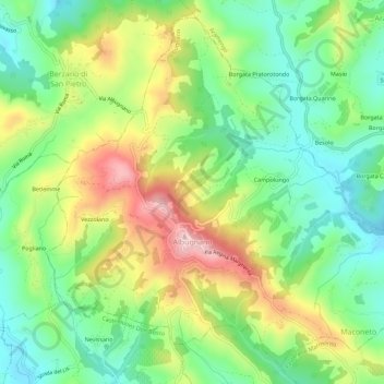
Name: Albugnano topographic map, elevation, terrain.
Location: Albugnano, Asti, Piemont, Italien (45.06511 7.94988 45.10110 8.00595)
Average elevation: 372 m
Minimum elevation: 264 m
Maximum elevation: 543 m
Die Gemeinde liegt etwa 35 Kilometer nördlich von Asti und 20 Kilometer östlich von Turin auf einer Höhe von 549 m und wird auch oft als der Balkon des Monferrato bezeichnet.
Other topographic maps
Click on a map to view its topography, its elevation and its terrain.
Cassinasco
Italien > Piemont > Asti > Cassinasco
Cassinasco, Asti, Piemont, Italien
Average elevation: 312 m