
Make a donation
Gear up for your next adventure:
As an Amazon Associate, this site earns from qualifying purchases at no extra cost to you.
Teton Range topographic map
Click on the map to display elevation.
Make a donation
Gear up for your next adventure:
As an Amazon Associate, this site earns from qualifying purchases at no extra cost to you.
Teton Range
One reason the Teton Range is famous is because of the dramatic elevation profile visible from the eastern side, which rises sharply from 4,000 to 7,000 feet (1,200–2,100 m) above the valley floor. Unlike most mountain ranges, the east side of the Teton Range lacks significant foothills or lower peaks which might obscure the view. This is due to the presence of the Teton Fault at the base of the east slope as well as the range being too young to have eroded into soft hills. The Snake River flows southward through the valley before turning to the west and entering Idaho.
Make a donation
Gear up for your next adventure:
As an Amazon Associate, this site earns from qualifying purchases at no extra cost to you.
About this map
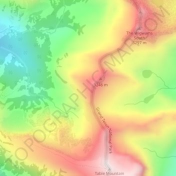
Name: Teton Range topographic map, elevation, terrain.
Location: Teton Range, Teton County, Wyoming, United States (43.75907 -110.85650 43.75917 -110.85640)
Average elevation: 2,985 m
Minimum elevation: 2,606 m
Maximum elevation: 3,372 m
Make a donation
Gear up for your next adventure:
As an Amazon Associate, this site earns from qualifying purchases at no extra cost to you.
Other topographic maps
Click on a map to view its topography, its elevation and its terrain.
Grand Teton National Park
United States > Wyoming > Teton County
Grand Teton National Park is named for Grand Teton, the tallest mountain in the Teton Range. The naming of the mountains is attributed to early 19th-century French-speaking trappers—les trois tétons (the three teats) was later anglicized and shortened to Tetons. At 13,775 feet (4,199 m), Grand Teton…
Average elevation: 2,409 m
Grand Teton National Park
United States > Wyoming > Teton County
Grand Teton National Park is named for Grand Teton, the tallest mountain in the Teton Range. At 13,775 feet (4,199 m), Grand Teton rises more than 7,000 feet (2,100 m) above Jackson Hole. The park has numerous lakes, including 15-mile-long (24 km) Jackson Lake as well as streams and the upper main stem of the…
Average elevation: 2,409 m
Make a donation
Gear up for your next adventure:
As an Amazon Associate, this site earns from qualifying purchases at no extra cost to you.
Jackson
United States > Wyoming > Teton County
Jackson is located at an elevation of 6,237 feet (1,901 m) above sea level. According to the United States Census Bureau, the town has a total area of 3.009 square miles (7.79 km2), of which 2.978 square miles (7.71 km2) is land and 0.031 square miles (0.08 km2) (1.03%) is water.
Average elevation: 2,043 m
Make a donation
Gear up for your next adventure:
As an Amazon Associate, this site earns from qualifying purchases at no extra cost to you.
Jackson
United States > Wyoming > Teton County
Jackson is located at 43°28′31″N 110°46′9″W / 43.47528°N 110.76917°W / 43.47528; -110.76917 (43.475, −110.769), at an elevation of 6,237 feet (1,901 m) above sea level. According to the United States Census Bureau, the town has a total area of 2.95 square miles (7.64 km2), of which 2.91…
Average elevation: 2,043 m
Jenny Lake
United States > Wyoming > Teton County
Jenny Lake is a starting point for many day and overnight hiking trips. The 7.1-mile (11.4 km) Jenny Lake Trail loops around the lake and is considered to be relatively easy due to the small altitude gain of 700 feet (210 m). However, the altitude increases rapidly once Cascade Canyon is entered.
Average elevation: 2,109 m
Make a donation
Gear up for your next adventure:
As an Amazon Associate, this site earns from qualifying purchases at no extra cost to you.
Wilson
United States > Wyoming > Teton County > Wilson
Wilson is located at 43°29′11″N 110°52′45″W / 43.48639°N 110.87917°W / 43.48639; -110.87917 (43.4863, -110.8793). at an elevation of 6,148 feet (1,874 m) above sea level.
Average elevation: 2,208 m
Make a donation
Gear up for your next adventure:
As an Amazon Associate, this site earns from qualifying purchases at no extra cost to you.
Jackson
United States > Wyoming > Teton County
Jackson is located at 43°28′31″N 110°46′9″W / 43.47528°N 110.76917°W / 43.47528; -110.76917 (43.475, −110.769), at an elevation of 6,237 feet (1,901 m) above sea level. According to the United States Census Bureau, the town has a total area of 2.95 square miles (7.64 km2), of which 2.91…
Average elevation: 2,043 m