
Maple Hill topographic map
Click on the map to display elevation.
Maple Hill
Maple Hill occupies a gently elevated setting in eastern Wabaunsee County, at about 974 feet (297 m) above sea level, where the town lies on a modest upland shoulder between broader lowlands and the nearby Flint Hills landscape. The surrounding terrain is characteristic of east-central Kansas: open, rolling prairie shaped by resistant limestone and chert-bearing layers, with thin rocky soils, rounded hilltops, and shallow stream-cut depressions rather than abrupt mountain relief. West and southwest of the town, local rises such as Maple Hill create the strongest relief, climbing above the flatter townsite and nearby road corridors, while the land eases eastward into lower, smoother ground. This physical setting reflects the wider Flint Hills pattern, where cherty gravel helps protect hillcrests from erosion, narrow valleys form where streams cut limestone, and broader gentler valleys appear where weaker shale is exposed, giving Maple Hill a quiet but distinctly undulating prairie topography.
About this map
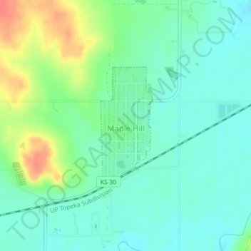
Name: Maple Hill topographic map, elevation, terrain.
Location: Maple Hill, Wabaunsee County, Kansas, United States (39.07862 -96.03154 39.09129 -96.02440)
Average elevation: 298 m
Minimum elevation: 280 m
Maximum elevation: 340 m
Other topographic maps
Click on a map to view its topography, its elevation and its terrain.