
Make a donation
Gear up for your next adventure:
As an Amazon Associate, this site earns from qualifying purchases at no extra cost to you.
Schwifting topographic map
Click on the map to display elevation.
Make a donation
Gear up for your next adventure:
As an Amazon Associate, this site earns from qualifying purchases at no extra cost to you.
Schwifting
In der Gemeinde gibt es 32 sozialversicherungspflichtige Arbeitsplätze. 344 Einwohner stehen in einem versicherungspflichtigen Arbeitsverhältnis, so dass die Zahl der Auspendler um 312 höher ist als die der Einpendler (Stand 30. Juni 2014).
Make a donation
Gear up for your next adventure:
As an Amazon Associate, this site earns from qualifying purchases at no extra cost to you.
About this map
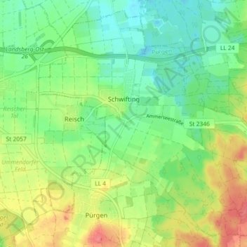
Name: Schwifting topographic map, elevation, terrain.
Average elevation: 634 m
Minimum elevation: 608 m
Maximum elevation: 673 m
Make a donation
Gear up for your next adventure:
As an Amazon Associate, this site earns from qualifying purchases at no extra cost to you.
Other topographic maps
Click on a map to view its topography, its elevation and its terrain.
Make a donation
Gear up for your next adventure:
As an Amazon Associate, this site earns from qualifying purchases at no extra cost to you.
Geretshausen
Deutschland > Bayern > Landkreis Landsberg am Lech
Das Pfarrdorf liegt etwa eineinhalb Kilometer ostsüdöstlich der Ortsmitte von Weil auf einer Höhe von 591 m ü. NHN. Naturräumlich befindet es sich im Lechrain am östlichen Hochufer des Verlorenen Baches, dem dort auch der Sägmühlbach und der Dorfgraben zufließen.
Average elevation: 588 m
Dettenschwang
Deutschland > Bayern > Landkreis Landsberg am Lech > Dießen am Ammersee
Das Pfarrdorf Dettenschwang liegt circa sechs Kilometer westlich von Dießen am Ammersee auf einem Höhenrücken in einer eiszeitlichen Jungmoränenlandschaft.
Average elevation: 675 m
Make a donation
Gear up for your next adventure:
As an Amazon Associate, this site earns from qualifying purchases at no extra cost to you.
Make a donation
Gear up for your next adventure:
As an Amazon Associate, this site earns from qualifying purchases at no extra cost to you.
Thalhofen
Deutschland > Bayern > Landkreis Landsberg am Lech > Landsberg am Lech
Average elevation: 641 m
Riederau
Deutschland > Bayern > Landkreis Landsberg am Lech > Dießen am Ammersee
Average elevation: 563 m
Make a donation
Gear up for your next adventure:
As an Amazon Associate, this site earns from qualifying purchases at no extra cost to you.
Hechenwang
Deutschland > Bayern > Landkreis Landsberg am Lech
Das Kirchdorf liegt auf einer Höhe von 594 m ü. NHN etwa zwei Kilometer südöstlich vom Gemeindehauptort Windach und zwei Kilometer westlich von Schondorf am Ammersee am Lauf der Schweinach.
Average elevation: 584 m
Oberbeuern
Deutschland > Bayern > Landkreis Landsberg am Lech > Dießen am Ammersee
Average elevation: 650 m
Lechrain
Deutschland > Bayern > Landkreis Landsberg am Lech > Denklingen > Guttenstall
Average elevation: 685 m
Make a donation
Gear up for your next adventure:
As an Amazon Associate, this site earns from qualifying purchases at no extra cost to you.
Erpfting
Deutschland > Bayern > Landkreis Landsberg am Lech > Landsberg am Lech
Average elevation: 628 m
Pessenhausen
Deutschland > Bayern > Landkreis Landsberg am Lech > Pessenhausen
Average elevation: 706 m
Make a donation
Gear up for your next adventure:
As an Amazon Associate, this site earns from qualifying purchases at no extra cost to you.
Dettenhofen
Deutschland > Bayern > Landkreis Landsberg am Lech > Dießen am Ammersee
Average elevation: 662 m