
Pauh topographic map
Interactive map
Click on the map to display elevation.
About this map
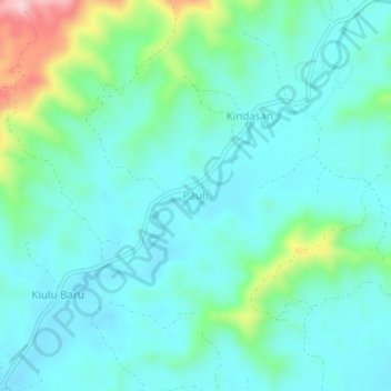
Name: Pauh topographic map, elevation, terrain.
Location: Pauh, Keningau, Interior Division, Sabah, Malaysia (5.29324 116.39017 5.33324 116.43017)
Average elevation: 429 m
Minimum elevation: 375 m
Maximum elevation: 643 m
Other topographic maps
Click on a map to view its topography, its elevation and its terrain.
Sri Telipok Baru
Sri Telipok Baru, Keningau, Sabah, Malaysia
Average elevation: 755 m
Batu 16-18 Jalan Sook
Batu 16-18 Jalan Sook, Keningau, Interior Division, Sabah, Malaysia
Average elevation: 434 m