
Parc Saint-Hubert topographic map
Interactive map
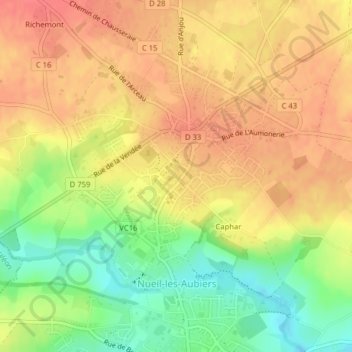
Click on the map to display elevation.
About this map
Name: Parc Saint-Hubert topographic map, elevation, terrain.
Average elevation: 138 m
Minimum elevation: 103 m
Maximum elevation: 161 m
Other topographic maps
Click on a map to view its topography, its elevation and its terrain.
Caphar
France > Nouvelle-Aquitaine > Deux-Sèvres > Nueil-les-Aubiers
Caphar, Nueil-les-Aubiers, Bressuire, Deux-Sèvres, Nouvelle-Aquitaine, France métropolitaine, 79250, France
Average elevation: 133 m