Geolocate

Niedenstein topographic map

Click on the map to display elevation.

About this map
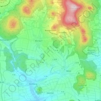
Name: Niedenstein topographic map, elevation, terrain.

Location: Niedenstein, Schwalm-Eder-Kreis, Hesse, 34305, Germany (51.18470 9.26437 51.25409 9.35352)

Average elevation: 294 m

Minimum elevation: 184 m

Maximum elevation: 559 m

Other topographic maps

Click on a map to view its topography, its elevation and its terrain.

Schwalmberg

Germany > Hesse > Schwalm-Eder-Kreis > Treysa

Average elevation: 232 m

Roseberg

Germany > Hesse > Schwalm-Eder-Kreis > Elbersdorf

Average elevation: 380 m

Gear up for your next adventure:

🧭Compass - Navigation compasses for outdoor exploration
🧯Animal Deterrent Spray - Safety spray for wildlife
🔪Multitools - Compact tools for outdoor use
🔥Ferrocerium Rod Fire Starters - Reliable fire lighting in wet or windy conditions without matches
📚Map Reading & Navigation Guides - Master the art of interpreting topographic contours and symbols

As an Amazon Associate, this site earns from qualifying purchases at no extra cost to you.