
Bamboo topographic map
Interactive map
Click on the map to display elevation.
About this map
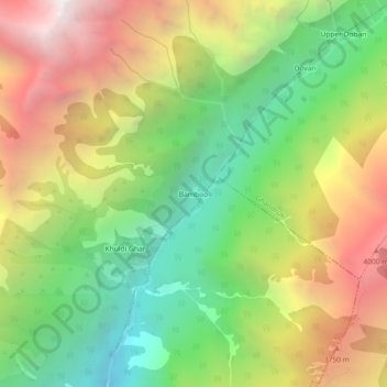
Name: Bamboo topographic map, elevation, terrain.
Location: Bamboo, Annapurna, कास्की, Gandaki, Népal (28.43684 83.83677 28.47684 83.87677)
Average elevation: 3,055 m
Minimum elevation: 1,971 m
Maximum elevation: 4,417 m
Other topographic maps
Click on a map to view its topography, its elevation and its terrain.
Jhinu Danda
Jhinu Danda, Annapurna, कास्की, Gandaki, Népal
Average elevation: 2,087 m