
Poussignac topographic map
Interactive map
Click on the map to display elevation.
About this map
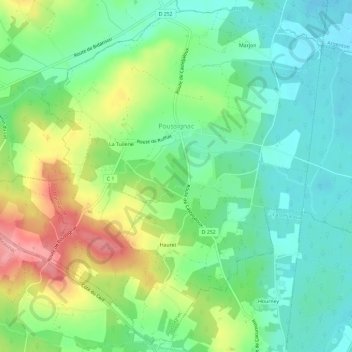
Name: Poussignac topographic map, elevation, terrain.
Average elevation: 87 m
Minimum elevation: 49 m
Maximum elevation: 158 m
Other topographic maps
Click on a map to view its topography, its elevation and its terrain.
Poudenas
France > Nouvelle-Aquitaine > Lot-et-Garonne
Poudenas, Nérac, Lot-et-Garonne, Nouvelle-Aquitaine, France métropolitaine, 47170, France
Average elevation: 108 m
Saint-Aman
France > Nouvelle-Aquitaine > Lot-et-Garonne > Saint-Eutrope-de-Born
Saint-Aman, Saint-Eutrope-de-Born, Villeneuve-sur-Lot, Lot-et-Garonne, Nouvelle-Aquitaine, France métropolitaine, 47210, France
Average elevation: 131 m
Aubiac
France > Nouvelle-Aquitaine > Lot-et-Garonne > Aubiac
Aubiac, Agen, Lot-et-Garonne, Nouvelle-Aquitaine, France métropolitaine, 47310, France
Average elevation: 134 m